Trips Places Foods Stories Newsletters
Loading...
Loading...
Loading...
Loading...

No search results found for
“”

Make sure words are spelled correctly.

Try searching for a travel destination.

Places near me Random place

Popular Destinations

  • Paris
  • London
  • New York
  • Berlin
  • Rome
  • Los Angeles
Trips Places Foods Stories Newsletters
Sign In Join
Places near me Random place
All the United States Idaho Three Island Crossing State Park
AO Edited

Three Island Crossing State Park

At the site of the most dangerous crossings on the Oregon Trail, a museum explores the complex history of westward migration in America.

Glenns Ferry, Idaho

Added By
slgwv
Email
Been Here
Want to go
Added to list
CAPTION
Three Island Crossing as seen from the embankment above the river to the south. This is also a unit of the state park.   slgwv / Atlas Obscura User
The old route of the Oregon Trail from the crossing.   slgwv / Atlas Obscura User
A prairie schooner by the museum entrance.   slgwv / Atlas Obscura User
A replica of a prairie schooner–a much lighter wagon than the Conestoga in the eastern US.   slgwv / Atlas Obscura User
The prairie schooner from the back.   slgwv / Atlas Obscura User
Prairie schooner replicas.   slgwv / Atlas Obscura User
Old map of Three Island Crossing.   slgwv / Atlas Obscura User
The old ferryboat at Glenn’s Ferry.   slgwv / Atlas Obscura User
Capstan at the old site of Glenn’s Ferry.   slgwv / Atlas Obscura User
The old track leading down to Glenn’s Ferry.   slgwv / Atlas Obscura User
Entrance to the museum.   slgwv / Atlas Obscura User
Work for the emigrant woman.   slgwv / Atlas Obscura User
Looking across the Snake River at Three Island Crossing. The steeper trail running diagonally down to the right is the old wagon road to the Crossing.   slgwv / Atlas Obscura User
Native Americans trading.   slgwv / Atlas Obscura User
Work for the emigrant woman.   slgwv / Atlas Obscura User
A stuck or recalcitrant ox.   slgwv / Atlas Obscura User
The Hawken muzzle-loading flintlock rifle, the standard in the “mountain man” era.   slgwv / Atlas Obscura User
The necessities on the trail.   slgwv / Atlas Obscura User
The reality was just a bit different…   slgwv / Atlas Obscura User
The promoters’ tales to the emigrants often bore little resemblance to the truth.   slgwv / Atlas Obscura User
“Manifest Destiny” was in the air.   slgwv / Atlas Obscura User
Native American temporary shelter.   slgwv / Atlas Obscura User
Grilling a salmon.   slgwv / Atlas Obscura User
The Native American perspective.   slgwv / Atlas Obscura User
Oregon Trail marker at the park.   slgwv / Atlas Obscura User
Native American folkways.   slgwv / Atlas Obscura User
Dry goods ca. 1890 at the Glenn’s Ferry store.   slgwv / Atlas Obscura User
Ferryboats across the Snake.   slgwv / Atlas Obscura User
Gus Glenn, the mid-19th century ferry entrepreneur.   slgwv / Atlas Obscura User
The message under the lid is, “with barrels full of produce they couldn’t sell, thousands of farmers went broke. Many packed up and headed for free land out West. Breakables were often stowed in barrels of cornmeal.   slgwv / Atlas Obscura User
Been Here
Want to go
Added to list

About

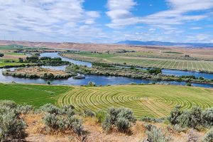
The Snake River rises in the Yellowstone area and flows generally westward to become the Columbia's largest tributary, joining the latter near the Tri-Cities in Washington state. West of Yellowstone it crosses Idaho through the Snake River plain.

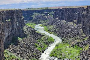
A west-flowing river sounds like it should have been a highway for the westbound emigrants, and to some degree it was. It was not an artery like the great rivers of the east, however. It is blocked by waterfalls in its upper reaches (of which the lowermost is Shoshone Falls). Even below the falls, it runs through deep canyons, often punctuated by rapids. Exasperated trappers, in the words of trapper Wilson Price Hunt, called it the Mad River in the early 19th century.

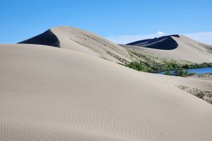
In an "adding injury to insult" sort of way, not far from the present Idaho state line the Snake turns abruptly north into Hell's Canyon, which was a deep, rapid-filled gorge, especially before the present dams. Hell's Canyon was even avoided by the trappers.

To continue westward, traffic had to leave the Snake. It did so at what the emigrants would later call Farewell Bend, where they went northwesterly, more or less along the route now followed by Interstate 84.

Nevertheless, a branch of the Oregon Trail followed the Snake River, because the alternatives weren't much better. This Idaho State Park is sited at the most dangerous crossing of the Snake. Wagons would descend the steep bluff to the south, and then would have to ford twice, between islands in the river, before floating across the main part of the stream. Many wagons were lost, and many animals—and people—were drowned in the attempt to make this crossing. What made the crossing even more stressful was that it was optional—parties could stay on the south side of the river, but that had dangers of its own: the route there was longer and much drier.

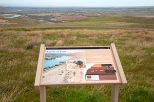
Today the park hosts a remarkably well-done museum on the history of the Oregon Trail, the travails of the emigrants, and—not least—the plight of the local Native Americans caught in the middle. The narrative avoids the triumphalist tone of traditional accounts about the march westward to fulfill Manifest Destiny. Instead, it highlights the desperation of the emigrants who were caught up in the economic depression of the late 1830s, and quotes some of the the promoters' exaggerations, distortions, and outright lies about the attractiveness of Oregon and the ease of the journey there.

Despite the profound collision of cultures, the Native Americans were usually very helpful to the emigrants. They traded extensively, the emigrants being happy to exchange such items as metal knives and clothing for food, and for assistance in making a safe crossing of the river. Before the dams of the 20th century, the Snake supported an extensive salmon run all the way up to Shoshone Falls, and the salmon were a major food source for the Indigenous people.

Unsurprisingly, tensions rose later when the emigrants started to stop and settle, rather than continue on to Oregon. The museum also recounts the sad saga of the Native Americans being forced onto reservations—with the added indignity that promises made by the U.S. Government were not kept, and that the ongoing efforts to "civilize" the "savages" continued into the 20th century, by such means as boarding schools that Indigenous children were forced to attend.

After a series of short-lived ferries, in 1870 Gus Glenn built a ferry here that eventually led to the name of the present town. An early ferryboat is also preserved in the park. It is said that Glenn had a Native American wife, and when Euro-American women became more common in the area he did not divorce his first wife to marry one of them. That such behavior was unusual is indicated by the fact it was a subject of comment.

Related Tags

Native Americans Museums Trails Rivers Islands State Parks

Know Before You Go

Three Island Crossing State Park is easy to find off Interstate 84 in Glenn's Ferry, Idaho. Take exit 120, go south under the freeway, and follow the signs. Check the website for current fees and hours.

To reach the Three Island Crossing Overlook across the river, take old US 30 (the frontage road) west 1.9 miles from its intersection with W Railroad Drive in Glenn's Ferry and turn left (south) onto Sailor Creek Road. Sailor Creek road doglegs to go across the railroad and then back again to cross the Snake on a bridge. After 0.7 miles, just across the bridge, bear left onto W Slick Ranch Road/Solosbal Road and go 3.4 miles. The road will go south and then bear east, climbing up to the bench that makes the bluffs. Turn left (north) at the marked intersection for the overlook. The overlook is about half a mile in on a well-graded road.

Community Contributors

Added By

slgwv

Published

December 17, 2024

Edit this listing

Make an Edit
Add Photos
Sources
  • https://www.nps.gov/places/000/three-island-crossing-state-park.htm
Three Island Crossing State Park
Glenns Ferry, Idaho, 83623
United States
42.944234, -115.317993
Visit Website

Nearby Places

Bruneau Dunes

Mountain Home, Idaho

miles away

Hagerman Fossil Beds

Hagerman, Idaho

miles away

Malad Gorge

Tuttle, Idaho

miles away

Explore the Destination Guide

Photo of Idaho

Idaho

United States

Places 67
Stories 12

Nearby Places

Bruneau Dunes

Mountain Home, Idaho

miles away

Hagerman Fossil Beds

Hagerman, Idaho

miles away

Malad Gorge

Tuttle, Idaho

miles away

Explore the Destination Guide

Photo of Idaho

Idaho

United States

Places 67
Stories 12

Related Places

  • The Upper Falls - in September (photo by Trent Wexler)

    Paradise, Michigan

    Tahquamenon Falls

    These dramatic cola-colored falls have appeared in a poem by Henry Wadsworth Longfellow and a song by Sufjan Stevens.

  • Whitefish Island ponds

    Sault Ste. Marie, Ontario

    Whitefish Island

    Amid rushing rapids, this small bit of land is an important First Nations site on border between Canada and the United States.

  • The replica on the shore of Hontoon Island.

    DeLand, Florida

    Hontoon Island Owl Totem

    The only ancient owl carving found east of the Mississippi.

  • Exterior of the Tasso Heritage Center

    Pepel, Sierra Leone

    Tasso Heritage Center

    A community heritage center on an overlooked island in the Sierra Leone River estuary.

  • The trestle from off the southeast abutment.

    Renslow, Washington

    Renslow Trestle

    A former railroad trestle over Interstate 90 has been refurbished for non-motorized traffic on the Palouse to Cascades trail.

  • Ostiglia, Italy

    Isola Boschina

    One of the biggest islands in the River Po is a protected nature reserve, reachable only by a seasonal ford rich with endemic fauna, fossils, and late 19th-century buildings.

  • Hagerman Fossil Beds National Monument

    Hagerman, Idaho

    Hagerman Fossil Beds

    An ordinary rancher stumbled upon one of the world’s largest collections of Pliocene horse fossils.

  • The Oasis Trail at the Agua Caliente Cultural Plaza.

    Palm Springs, California

    Agua Caliente Cultural Plaza

    An ancient mineral hot spring sits at the middle of this combination cultural center and spa.

Aerial image of Vietnam, displaying the picturesque rice terraces, characterized by their layered, verdant fields.
Atlas Obscura Membership

See Fewer Ads


Become an Atlas Obscura member and experience far fewer ads

Become a Member

Get Our Email Newsletter

Follow Us

Facebook YouTube Twitter Instagram Pinterest RSS Feed

Get the app

Download the App
Download on the Apple App Store Get it on Google Play
  • All Places
  • Latest Places
  • Most Popular
  • Places to Eat
  • Random
  • Nearby
  • Add a Place
  • Stories
  • Food & Drink
  • Itineraries
  • Lists
  • Puzzles
  • Video
  • Podcast
  • Newsletters
  • All Trips
  • Family Trip
  • Food & Drink
  • History & Culture
  • Wildlife & Nature
  • FAQ
  • Membership
  • Feedback & Ideas
  • Community Guidelines
  • Product Blog
  • Unique Gifts
  • Work With Us
  • About
  • FAQ
  • Advertise With Us
  • Advertising Guidelines
  • Privacy Policy
  • Cookie Policy
  • Terms of Use
Atlas Obscura

© 2025 Atlas Obscura. All Rights Reserved.